Topics Bachelor's theses in Earth and Climate Sciences
Bachelor's theses topics on research group websites
Bachelor's thesis topics in SiROP
Many research groups in the Department of Earth Sciences advertise Master's theses through the external pagestudent research project website SiROP.
The feed below shows a selection of currently available projects.
Examining glacier melt dynamics from streamflow observations
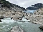
Glaciers are an essential freshwater resource, especially during warm and dry periods. Assessing the contributions of glacier melt to downstream discharge at daily to weekly scales is important to understand the susceptibility of mountain water supply to the ongoing and future projected glacier retreat. However, these contributions are difficult to obtain as glacier mass balance observations are typically multi-year, annual or seasonal measurements. Therefore, daily streamflow dynamics will be analysed.
Keywords
Glaciology, Hydrology
Labels
Bachelor Thesis , Master Thesis
Description
Goal
Contact Details
More information
Published since: 2024-02-15
Organization Glaciology (Prof. Farinotti)
Hosts Farinotti Daniel , van Tiel Marit
Topics Earth Sciences
Debris-flow velocity estimation in the lab using Particle Image Velocimetry

Debris flows are extremely rapid, flow-like landslides composed of boulders, woody debris as well as a viscous slurry. They are an important geomorphic process which transport sediment to the river system as well as a significant hazard to infrastructure and people. For the process characterization, hazard assessment and early warning, debris-flow monitoring is important but challenged by the harsh conditions of alpine environment in which they occur. One monitoring technique is with cameras, for which the output is useful for a number of applications such velocity estimations or object detection techniques. However, the fast movements and various light conditions often lead to low-quality data. In this project, a debris-flow monitoring setup will be deployed in the lab. The setup includes a high-speed camera and a small flume (Fig. 1), where small debris flows can be artificially initiated. The student will conduct a series of tests in different light conditions and camera settings. The recordings will be used to estimate debris-flow velocities through Particle Image Velocimetry (PIV, e.g., Theule et al., 2018), which is an optical method often used to estimate flow velocities at high resolution (Fig. 2). Finally, the student will identify the optimal camera settings as well as associated uncertainties in different light conditions. These experiments will provide important insights to the accuracy of the devices and methods used, as well as support future decisions regarding monitoring setups.
Labels
Bachelor Thesis
More information
Published since: 2023-11-29 , Earliest start: 2024-03-01 , Latest end: 2024-06-30
Organization Engineering Geology
Hosts Hirschberg Jacob
Topics Earth Sciences
Automated debris characterization of the Brienz landslide using machine- learning assisted image segmentation
For engineering geological purposes, one often needs to characterize and classify a sediment or soil material, which requires the assessment of a set of parameters like grain size, grain shape, angularity. However, obtaining reliable and representative data for these parameters can be challenging, especially for large areas or complex terrains. Traditional methods of mapping and classification often require manual labor and field work, which can be time-consuming, costly, and – particularly in the absence of laboratory testing – be prone to human error or bias. Moreover, these methods may not capture the spatial variability and heterogeneity of the sediment or soil properties across the area of interest. To be able to cover larger areas we use drones to obtain high resolution optical images and elevation data. These images can then be processed using a machine-learning assisted image segmentation technique, allowing to extract the outlines of individual sediment grains for the entire area (Fig. 1). Based on these outlines, we can then compute various parameters for each grain, such as its size, shape, angularity, and orientation. Furthermore, we can analyze the distribution and statistics of these parameters for the whole area and use them to identify and describe the sediment characteristics for different sub-regions. In this project, we apply this drone-based approach to the landslide deposit that resulted from the event that occurred in Brienz/Brinzauls on June 15th 2023 (Fig. 2). The student will apply an existing python script and workflow to this data set and extract grain size distributions and potentially other parameters. Prior knowledge of python is not required and the student would not need to write much new own code, but an interest in coding is advantageous. Furthermore, a GIS software (QGIS or ArcGIS Pro) and potentially a photogrammetry software for drone footage analysis will be used. Depending on the exact timing of the project and the weather conditions at that moment a few days of field work will be planned to either acquire additional drone footage or ground truth the obtained sediment distributions.
Labels
Bachelor Thesis
More information
Published since: 2023-11-29 , Earliest start: 2024-03-01 , Latest end: 2024-06-30
Organization Engineering Geology
Hosts de Palézieux Larissa, Dr
Topics Earth Sciences
Thermo-mechanical response of Rotondo Granite with different cooling treatments
Geothermal energy is playing a pivotal role in the transition of the Swiss energy sector from reliance on fossil fuels and nuclear power to sustainable sources. Aligning with this, the Bedretto Underground Laboratory serves as a testbed for hydraulic stimulation experiments that are essential for enhancing the permeability of Enhanced Geothermal Systems (EGS). In addition to hydraulic stimulations, the temperature discrepancy between the injection fluid and the hot reservoir rock can induce thermal fractures due to rapid cooling near the injection wells and slower cooling in the more distant field. It is vital to quantify the deterioration of the reservoir rock mechanical strength caused by thermal cracking to ensure the structural integrity of injection and production wells in EGS. This study aims to investigate the mechanical response of Rotondo Granite, sourced from the Bedretto lab. Uniaxial compressive strength (UCS) tests will be performed on specimens treated under various temperature and cooling conditions at the Rock Mechanics and Physics Lab (RPM Lab) (Figure 1b). Heat treatments will include increasing the temperature from 25 °C to 800 °C using a high temperature furnace, followed by both rapid and slow cooling. The results of this study will provide a comprehensive data set describing the mechanical strength deterioration of Rotondo Granite following heating and cooling treatments. The student will learn how to prepare rock specimens, conduct UCS tests, and interpret the mechanical properties (Young’s Modulus, Poisson’s Ratio, and UCS) of the reservoir rock according to ISRM standards. Necessary training will be provided on preparing the testing specimens, setting up testing equipment, data acquisition systems and analyzing the test results.
Labels
Bachelor Thesis
More information
Published since: 2023-11-29 , Earliest start: 2024-03-01 , Latest end: 2024-06-30
Organization Engineering Geology
Hosts Vidanage Radhika
Topics Earth Sciences
Rockfall statistics at the Spitze Stei instability, Kandersteg
In Alpine regions, large rock slope instabilities pose a major hazard to settlements and touristic sites. One current case in Switzerland is the “Spitze Stei” instability above the popular tourist site Oeschinensee (Kandersteg, BE). The rock formation around the Spitze Stei consisting of nearly 18 Mio. m3 of limestone and marls move at high rates of up to several centimeters per day. Given the high risk associated with a potential failure of a large portion of the instability, the rock mass is monitored with a multisensor monitoring system including a georadar, several reflectors continuously measured with a total station, several GPS stations, a weather station, time-lapse cameras, etc. Additionally, frequent drone surveys are performed to record photogrammetric digital terrain models (DTMs). The monitoring system is the basis of an early warning system and allows detection of accelerations as well as frequent rockfall and occasional smaller rockslide events with good spatial and temporal coverage. The goal of this BSc project is to investigate rock fall activity based on the analysis of DTMs, radar data and photos and create a database on occurrence time, volume, location, corresponding compartment of the instability, etc. The collection of rock fall and smaller rockslide events is then analysed in terms of frequency-volume statistics. If possible, the statistical distribution of rock falls is resolved in terms of their spatial and temporal occurrence, with the goal of uncovering a connection between rockfall activity and meterological drivers. Further, it may be possible to detect potential increases of rockfall activity prior to a larger events thus exploring their role as precursors
Labels
Bachelor Thesis
More information
Published since: 2023-11-24 , Earliest start: 2024-03-01 , Latest end: 2024-06-30
Organization Engineering Geology
Hosts Gischig Valentin
Topics Earth Sciences